
Updates
on everything Geocodio
Need MSAs and CSAs?
Metropolitan/Micropolitan Statistical Areas and Combined Statistical Areas. Improved timezones. Project spotlight.
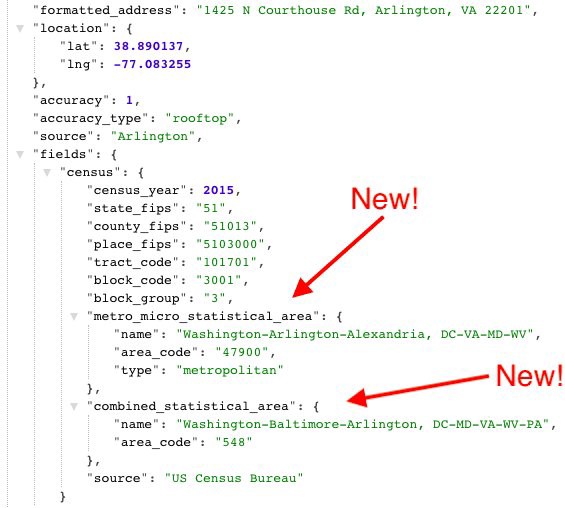
NEW! Metropolitan/Micropolitan Statistical Areas and Combined Statistical Areas
Where delineated by the Census Bureau, we now return Metropolitan/Micropolitan Statistical Areas and Combined Statistical Areas. These fields are included when you request the census data field.
This data is now available via spreadsheet upload and API. For API implementation, please see our documentation.
IMPROVED! Timezones
We now return timezone information in a tzdb-compliant format, including:
Standardized name of the timezone
Abbreviation
UTC/GMT offset
whether the location observes Daylight Saving Time (DST)
If you’re using our API, you’ll need to upgrade to version 1.3 to see the new results (see documentation). No changes are needed if you’re uploading spreadsheets.

Project Spotlight
Have you ever wondered which Manhattan subway stations have the greatest variety of dining options around them, or which stations have the cleanest restaurants nearby? Geospatial Data Scientist Vanessa Mateus made maps with data from Geocodio and other sources to determine just that. Check out the project here.
Have a project you’d like us to highlight? Send it over to [email protected]!
Related
FFIEC Data Append Now Available In Beta
Customers now have access to key datapoints from the FFIEC flat file, including Income Level, Urban/Rural code and more.
Lists API Now Available for Enterprise
Enterprise customers can now upload a spreadsheet directly via the Lists API.
Maps Now Available for Enterprise
Enterprise customers can access mapping tools to visualize location data.
Ridings for Canada's 2025 Election
Updated electoral districts (ridings) are available for Canada's 2025 elections.
Don't miss what's new
Geocodio ships new features and data updates regularly. We'll only email you with the good stuff, nothing else.
Thanks for subscribing! Check your inbox to confirm.