

Turn addresses into accurate district data at scale.
Even when the maps just changed.
Match addresses to Congressional districts, state legislative districts, Canadian ridings, and legislator contact information.
Whether you have 500 addresses or 50 million, Geocodio can handle it.


Politics moves fast.
The data has to keep up.
Voter files, member lists, donor records, and advocacy form submissions all have to land in the right Congressional district, the right state legislative district, and in front of the right legislator. The work is high stakes, the volume can be enormous, and the maps are changing constantly these days.
Geocodio matches at the street address (and even unit) level whenever the data allows it and independently tracks redistricting so voters are placed in the right location and the right district.
Refresh districts without re-geocoding the whole list
Every result includes a stable address identifier, a key that stays the same for that address even as the data behind it changes. Send back the keys and get the updated district data without paying to geocode the addresses a second time.
Unit-level geocoding so canvassers aren't wandering around
Geocodio provides unit-level geocoding to accurately place addresses in mobile home parks, college campuses, retirement communities, and other large complexes.
District matching from ZIP codes
Only have ZIP codes? Geocodio will return the most likely Congressional and state legislative districts with a proportion key so you know what you're working with.
All of the data you need to match voters with their districts and representatives
+
This is just a sample of the district and legislator data you can get back from Geocodio. And all of it in one request.
All of the data you need to match voters with their districts and representatives
+
This is just a sample of the district and legislator data you can get back from Geocodio. And all of it in one request.
County
Congressional Districts (113th–120th Congress)
State House District Name & Number
State Senate District Name & Number
OCD-IDs
Congress Member Name
Congress Member Party
Congress Member Photo
Congress Member Phone Number
Congress Member Contact Form URL
State Legislator Name
State Legislator Party
State Legislator Photo
State Legislator Office Phone Number
State Legislator Email
State Legislator Contact Form
Provincial/Territorial Riding Name (English and French)
Federal Riding Name (English and French)
School District Name
School District LEA Code
"We are in a space where it's almost impossible to get accurate data, and we never worry about the data we get from Geocodio."
Debra Cleaver, Founder, VoteAmerica
We're watching redistricting so your results are always accurate
Geocodio independently tracks redistricting at both the Congressional and state legislative level across all 50 states. See our redistricting tracker
Show your footprint by district
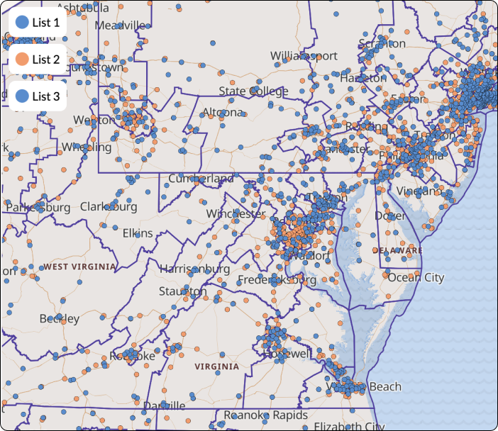
Advocacy teams use Geocodio to map their membership lists and overlay the results on congressional and state legislative district boundaries. Make your impact visible, district by district.
Upload addresses, add the overlay, and download a presentation-ready map. That's it.
Presentation-ready maps with built-in district layers are included with all spreadsheet uploads (up to 100,000 points). Share a link or download as PNG or PDF.
Create a free account
VoteAmerica builds free, publicly available tools to help Americans navigate the complexity of voting.
"It just works. That's probably the best thing you can say about software."
Debra Cleaver, Founder and CEO
VoteAmerica
Who They Are
VoteAmerica is a nonpartisan nonprofit that builds free, publicly available tools to help Americans register to vote, find their polling place and the date of their next election, request absentee ballots, and more. Since voting in the United States is tied to a physical address, reliable geocoding and data enrichment are essential to everything VoteAmerica does.
The Challenge
VoteAmerica needs to reliably match voter addresses to physical locations and to up-to-date congressional and state legislative districts. Many providers only update district boundaries with each Census, but redistricting happens far more often. Outdated boundaries mean voters get the wrong election information.
Reliability was just as critical. VoteAmerica's tools need to handle enormous traffic spikes on Election Day, when millions of Americans are looking up their polling place at once. Other providers imposed query limits that throttled access at exactly the wrong time.
The Solution
In a single API call, VoteAmerica retrieves coordinates, county data, and current congressional and state legislative districts. "It's as simple as adding another parameter to the API request," says Emily Behlmann, Director of Engineering. Geocodio independently tracks redistricting and updates its data as new maps are passed. "I'm not sure who else would be as up to date as Geocodio, because it's a lot of work," Debra says.
The Results
VoteAmerica has relied on Geocodio as a core part of their toolbox for over a decade, processing millions of voter records annually, including on Election Day, without throttling or downtime. "We are in a space where it's almost impossible to get accurate data, and we never worry about the data we get from Geocodio," Debra says.
Strong Foundations: A Playbook for Housing and Economic Growth
Learn more about Strong Foundations: A Playbook for Housing and Economic Growth

Stopped, Fined, Arrested: Racial Bias in Policing and Traffic Courts in California
Learn more about Stopped, Fined, Arrested: Racial Bias in Policing and Traffic Courts in California

Brnovich v. Democratic National Committee
Learn more about Brnovich v. Democratic National Committee
Measuring Alcohol Outlet Density: A Toolkit for State and Local Surveillance
Learn more about Measuring Alcohol Outlet Density: A Toolkit for State and Local Surveillance
The Importance of Technology Investments for Community Bank Lending and Deposit Taking During the Pandemic
Learn more about The Importance of Technology Investments for Community Bank Lending and Deposit Taking During the Pandemic

Donating to the District Attorney
Learn more about Donating to the District Attorney

Tax Incentives and the Supply of Low-Income Housing
Learn more about Tax Incentives and the Supply of Low-Income Housing
Closing Detroit’s Appraisal Gap: A Market-Based Strategy to Revive Vacant Neighborhoods – Lessons for Struggling Cities Across the Nation
Learn more about Closing Detroit’s Appraisal Gap: A Market-Based Strategy to Revive Vacant Neighborhoods – Lessons for Struggling Cities Across the Nation
Related Resources
Redistricting Tracker
Track the latest redistricting updates for Congressional and state legislative districts.
API Documentation
See how to add Congressional districts, state legislative districts, and Congressional contact information via our API.
How to Add Congressional Contact Info to Addresses & Integrate with MailChimp
This guide walks you through how to take a list of addresses, add Congressional contact information, and integrate with MailChimp.
Convert ZIP Codes to Congressional Districts
Only have ZIP codes? You can still convert them to Congressional districts (with caution).
Make a Map with Congressional Districts
How to turn addresses into a map with Congressional districts overlaid.
Addresses to Canadian Ridings
Working with Canadian addresses? We can convert your addresses or coordinates to ridings (Canadian federal and provincial electoral districts).
Addresses to State Legislative Districts
How to add state house and senate districts to addresses via spreadsheet or API.
By the time you finish reading this page, the Geocodio API will have processed 5.3 million lookups.
Your data could be next...