

Get FIPS codes and FFIEC income data. In minutes, not hours
Geocodio standardizes and enriches address data with coordinates, historical Census tracts, FFIEC income levels, demographics, and more. Upload a spreadsheet or use the API. Store and reuse most results however you want.
Compliance reporting often means pulling data from multiple sources, matching it by hand...and doing it all over again when you realize the the Census vintage was incorrect.
Addresses to FIPS codes from one place, FFIEC income levels from another, demographic data from a third. Some of those services go down without warning. Some limit how long you can store the results. And at least one requires a while loop just in case the API doesn't respond.
One request. All of the data you need.
With one click, Geocodio lets you join addresses with FIPS codes (Census tracts and block groups), FFIEC income categories (low, medium, high), urban/rural codes, CRA poverty criteria, CRA unemployment criteria, CRA distressed and remote rural designations, ACS demographic data, and more.
Historical Census geographies are available back to 2010 and 2000 for analyses that require a specific vintage.
Know what you're getting.
Every result includes the Census year, an accuracy score, and an accuracy type, so you know exactly how much to trust each match before it goes into a model or a regulatory filing.
Built for high-volume analysis.
- Predictable processing times, even for portfolios of 1 million+ addresses
- No restrictions on storing or reusing North American data or any forward geocoding results. (Restrictions only on UK reverse geocoding.)
- Upload a spreadsheet or integrate through the API. Same data either way.
On-premises deployment is available for organizations that require it.
Built for regulated industries
SOC 2 Type II audited annually with on-premises available. Resilient infrastructure. Full encryption. Minimal restrictions on results storage or reuse.
Security
Geocodio's Enterprise platform undergoes annual SOC 2 Type II audits and third-party penetration testing. All data is encrypted in transit and at rest.
SSO is included with all Enterprise plans.
For organizations that need full control, an on-premises option is available. No calls or data ever leave your infrastructure.
Data retention
On Geocodio's Enterprise platform, the contents of API requests are never stored.
Spreadsheet uploads are automatically deleted 72 hours after processing, and you can permanently delete uploads at any time from the dashboard.
Privacy
Enterprise platform accounts can sign a Data Processing Agreement (DPA) or Business Associate Agreement (BAA) for HIPAA-covered data.
Custom contracts are available for organizations with specific privacy requirements.
Data Storage
Many geocoding providers restrict storage or commercial use of results. Geocodio does not.
For North American data, there are no restrictions on how you store, integrate, or reuse data returned by Geocodio. This includes FIPS codes, Census tracts, FFIEC data, coordinates, standardized and completed addresses, and all other data appends.
Accuracy
Geocodio's average accuracy score is .981. Given a dataset randomly spread across the US, you can expect 90% to come back with rooftop, point, or range interpolated results, which customer-provided benchmarking shows to be industry standard.
Over 3,000 datasets power Geocodio's geocoding engine, and datasets are refreshed multiple times per week. New datasets are added regularly.
Uptime
Geocodio processes over 2 billion lookups per month across redundant, geographically distributed infrastructure. Average uptime exceeds 99.99%.
Self-healing systems, 24/7 on-call monitoring, and blue-green deployments keep the service running with zero-downtime updates. Add-on SLAs are available for Enterprise accounts. Subscribe to status updates
Visualize your loan book by FFIEC income indicators
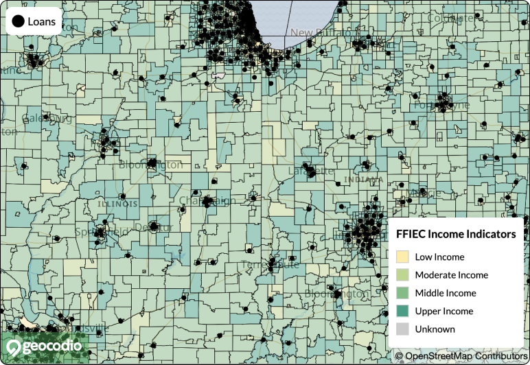
Compliance teams use Geocodio to upload loan addresses and plot them with FFIEC income indicator layers at the Census tract level. Built-in shading for income categories used in CRA and fair lending analysis.
Upload addresses, add the overlay, and download a presentation-ready map. That's it.
Maps are included with all spreadsheet uploads (up to 100,000 points). Share a link or download as PNG or PDF.
-(1).png)
Mortgage iQ CRM is an enterprise CRM built for the mortgage lending industry. It helps lenders manage leads, automate marketing, and streamline client relationships across retail, wholesale, and consumer direct channels.
"Geocodio is very easy to work with as a partner and solution. We've integrated with hundreds of products in our almost-30 years in the business and with Geocodio integration is simple, with great support. The price point and pricing structure is also very accommodating and allows us to easily trial a new customer without significant cost."
Chris King, President and Founder
Mortgage iQ CRM
Who They Are
Mortgage iQ CRM helps mortgage lenders increase their revenue by improving the effectiveness of their sales and marketing efforts. Founded in 1992, their hybrid technology and consulting services help retail and wholesale lenders find more profitable clients and identify business process gaps.
Using MiQ's robust CRM, lead management and marketing platform, mortgage lenders can assign territories to both retail loan officers as well as wholesale account executive sales teams. Geographic targeting for account assignment is key to helping mortgage sales professionals become more effective.
The Challenge
Before its integration of Geocodio, MiQ was limited to using states, counties, and ZIP code data for geographic targeting. In many cases these points just weren't targeted enough to help customers create the precise sales territories needed in order to obtain next-level results.
The Solution
Now, using geocoding and the Haversine Distance Formula, MiQ can create criteria based on geographic radiuses in their databases to help originators find local real estate agents to drive new business and help loan officers prioritize their work by tracking in-progress loans within their territory.
The Results
"Geocodio is very easy to work with as a partner and solution. We've integrated with hundreds of products in our almost-30 years in the business and with Geocodio integration is simple, with great support. The price point and pricing structure is also very accommodating and allows us to easily trial a new customer without significant cost."
Pricing
Create a free demo account to try it for yourself—the first 100 lookups are free
Enterprise Flex
$5,000
/year
25,000 lookups included per month then $2/1,000. Includes all data appends and distance calculations. All data stays within the US.
Enterprise Unlimited Geocoding
$3,250
/month
Dedicated instance of the Geocodio geocoding platform exclusively for your organization's use. (Does not include distance.)
On Premises
Contact Us
Private and isolated on your own infrastructure. No internet connection required.

Asurity adds Geocodio as primary geocoding solution for RiskExec
Learn more about Asurity adds Geocodio as primary geocoding solution for RiskExec

Inferring Ethnicity, Quantifying Disparate Impact, and Fair Lending Compliance
Learn more about Inferring Ethnicity, Quantifying Disparate Impact, and Fair Lending Compliance

Bank Relationships and the Geography of PPP Lending
Learn more about Bank Relationships and the Geography of PPP Lending
The Importance of Technology Investments for Community Bank Lending and Deposit Taking During the Pandemic
Learn more about The Importance of Technology Investments for Community Bank Lending and Deposit Taking During the Pandemic

Describing the distribution of Emergency Rental Assistance funds to those who need and qualify for it
Learn more about Describing the distribution of Emergency Rental Assistance funds to those who need and qualify for it

Tax Incentives and the Supply of Low-Income Housing
Learn more about Tax Incentives and the Supply of Low-Income Housing
Related Resources
Download a Sample File
Download a sample spreadsheet of addresses with FIPS codes, Census blocks, MSAs, and other Census geographies added.
Census Demographic Percentages for ECOA BISG Calculations
Append Census demographics with percentages already calculated.
Add FIPS Codes, Blocks/Tracts, and MSAs to Addresses
Geocodio can help you add FIPS codes, blocks, and tracts to addresses going back to the 2010 Census year.
Privacy
We never share, sell, or otherwise give third parties access to your data.
Upload a Test
The first 2,500 lookups are free, no credit card or free trial plan required. See if Geocodio is the right solution for you before getting budget approval.
FFIEC Geocoder Alternative
Geocodio is a faster way to bulk lookup Census tracts, blocks, and FIPS codes for addresses.
Why Geocodio's Results Sometimes Differ from the FFIEC
Geocodio is more accurate than the US Census Bureau/FFIEC geocoder, which occasionally leads to differences in results.
Prove that it works before you loop in procurement
Try it for yourself with a test file. Free for up to 2,500 lookups per day, no credit card or commitment required.